You are using an out of date browser. It may not display this or other websites correctly.
You should upgrade or use an alternative browser.
You should upgrade or use an alternative browser.
usa in an expansionist style? that's unusual in a map but it looks good 😄
looking like some yankee domination era
i've always thought of it like a spider leg 😂😂I've for some reason get bothers seeing the US without the Baja California. Idk why
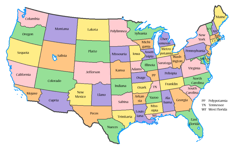
View attachment 550732
There are some modified state borders depicted.usa in an expansionist style? that's unusual in a map but it looks good 😄
looking like some yankee domination era
The 500 States of America, each with population 600k +/- 60k. No more overrepresentation in Congress or the Electoral College. And a booming industry for new state flags, birds, gemstones, etc.
Crazy Boris
Banned
Give the Kentucky bend to Tennessee so it’s connected to its own state.
Erie Triangle to New York. Sorry, Pennsylvania. I just think it looks better as NY.
Do something to Wyoming just to make it a different shape from Colorado.
Upper Penninsula to Wisconsin maybe?
Erie Triangle to New York. Sorry, Pennsylvania. I just think it looks better as NY.
Do something to Wyoming just to make it a different shape from Colorado.
Upper Penninsula to Wisconsin maybe?
Do you not know what the Appalachian Mountains are?Step 2 : Tennessee merged into North Carolina
Something Pennsylvania and New York fully ignoreDo you not know what the Appalachian Mountains are?
")
Only because their lands were laid out before being properly surveyed. If you want to have better functional borders, Tennessee as a part of North Carolina is stupid.Something Pennsylvania and New York fully ignore
What is this “functional” business and why does it intrude upon borders, which everyone knows are purely aesthetic?If you want to have better functional borders,
Also, the missing northeast corner of Arkansas should be swapped over from Missouri.
You mean something that specifically centers on North America? Because if soDoes anyone have a good map I could use to make borders with? Maybe a Q-Bam?
1. Why limit yourself in such a way? The United States of America must become the United States.
2. Why not just use a standard base map from the blank map thread?
Starforce
Banned
You mean something that specifically centers on North America? Because if so
1. Why limit yourself in such a way? The United States of America must become the United States.
2. Why not just use a standard base map from the blank map thread?
How would it be limiting? And standard base maps don't do it justice for me. If I'm going to make a map I want one to look good.
Make Manhattan it's own state becausethe mayor of New York pretty much runs at like his own state. The governor of New York does not like it because technically he can.
Split California into northern and southern California, northern California would like that except they would have to get San Francisco in order to maintain a sufficient tax base. Merge northern Idaho with Washington because northern Idaho in southern Idaho don't get along. Combine Alabama and Mississippi into one state, because running one state government would be cheaper and those states are always broke.
Split California into northern and southern California, northern California would like that except they would have to get San Francisco in order to maintain a sufficient tax base. Merge northern Idaho with Washington because northern Idaho in southern Idaho don't get along. Combine Alabama and Mississippi into one state, because running one state government would be cheaper and those states are always broke.
Starforce
Banned
I have a list of things I would most certainly do. I can't be bothered to make a full map of this, maybe I will soon.
- Northern US border would look like this. https://www.alternatehistory.com/fo...-us-border.138050/#lg=attachment83179&slide=0 (won't work as an image)
- Partition New York like this. Ignore the numbers. As a New Yorker I feel no connection whatsoever to the city, it misrepresents the area in which I live so I have done what I feel is right.

- Partition California much like this

- Every large city, something like cities with a population over a million or something would become independent city states within the Union.
- Split Florida North and South, while taking away the coastlines of Alabama and Mississippi, combining them with the Florida panhandle to create the state of West Florida.
- The rest of the states would be much like this. Though Ohio here would keep its current name, my previous borders I listed would be in effect, states with names of current states in other locations would be changed. North Carolina and Virginia's borders would be as they are in our world, with West Virginia existing aswell. The 4 corner states would exist as OTL.
- The Philippines would be split into 3 different states and be a part of the US.
- Puerto Rico wouldn't be a state, it'd be sold back to Spain.
- US territories in the pacific become states.
- Kamchatka Peninsula to be American.
- Ryuku islands to be American.
- Northern US border would look like this. https://www.alternatehistory.com/fo...-us-border.138050/#lg=attachment83179&slide=0 (won't work as an image)
- Partition New York like this. Ignore the numbers. As a New Yorker I feel no connection whatsoever to the city, it misrepresents the area in which I live so I have done what I feel is right.
- Partition California much like this
- Every large city, something like cities with a population over a million or something would become independent city states within the Union.
- Split Florida North and South, while taking away the coastlines of Alabama and Mississippi, combining them with the Florida panhandle to create the state of West Florida.
- The rest of the states would be much like this. Though Ohio here would keep its current name, my previous borders I listed would be in effect, states with names of current states in other locations would be changed. North Carolina and Virginia's borders would be as they are in our world, with West Virginia existing aswell. The 4 corner states would exist as OTL.
- The Philippines would be split into 3 different states and be a part of the US.
- Puerto Rico wouldn't be a state, it'd be sold back to Spain.
- US territories in the pacific become states.
- Kamchatka Peninsula to be American.
- Ryuku islands to be American.
Share: